 Lokesh Chaturvedi at RCRA hearings, 03/02/99) in the WIPP air intake shaft (EEG-61, 1996, p. 2-6), and in seven test wells in the immediate vicinity of the waste panels (CCA, Figure 3-9) -- H-1, H-2, H-3, WQSP-6, WQSP-6a (EEG-61, 1996, p. 2-6), H-14, and H-16 (SAND 88-0157, p. 81). One of these wells, H-1, is located directly above the waste panels (CCA, Figure 3-9). In addition, lost circulation of drilling fluid in the Dewey Lake Redbeds has been reported at ERDA-9 (USGS memo, Jerry W. Mercer to William P. Armstrong, 06/21/76), P-1 (Jones, USGS Open File Report 78-592,), DOE-2 (Lokesh Chaturvedi, personal communication, 01/22/86, cited by Phillips, 1987, p. 51), WIPP-33 (SAND 80-2011, pp. 11, C-3), WIPP-25 (SAND __-____, p. 7), and H-7c (SAND __-____, p. 13).
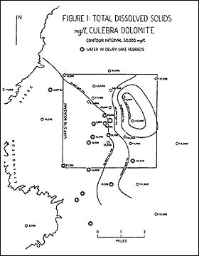
DOE states that “no Dewey Lake water has been mapped in the vicinity of the WIPP shafts” (Comment No. 273.X.A.3.a., p. 20). To the contrary, Phillips (1997b, Figures 1 and 2) [Exhibit 34 and Exhibit 35] mapped encounters of water in the Dewey Lake Redbeds at nine locations within the WIPP site, including the WIPP shafts themselves, and at six other locations within 2.5 miles of the WIPP site boundary. The maps show that these wells are clustered in the south-central part of the WIPP site and south of the site, where the water in the
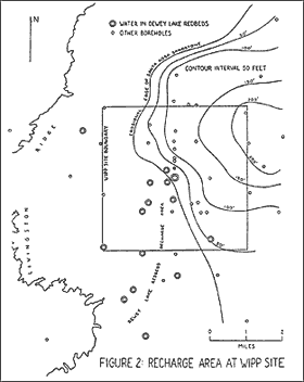 Culebra dolomite is freshest (Figure 1), and the Santa Rosa sandstone is absent (Figure 2). This indicates that the recharge area for the Dewey Lake Redbeds and the Rustler Formation is within and near the WIPP site, everywhere that the Santa Rosa sandstone is not present (Phillips, 1997b, p. 6) (Phillips, 1998a, pp. 22-23).
DOE stated that the Dewey Lake “exhibits no flow at the WIPP site.” (EPA Docket # A-93-02, Item # III-B-3, p. 65). To the contrary, the Dewey Lake Redbeds produced 25 gallons per minute at test well P-9 (the H-11 hydropad), 28 gallons per minute at WQSP-6, and 12 gallons per minute at WQSP-6a, all within the WIPP site (EEG-61, p. 2-6), and 12-15 gallons per minute at H-4c (CCA, Table USDW-4), 446 feet outside the WIPP site boundary (CCA, Appendix BH).
According to Sandia Labs, “the transmissivity of a saturated fractured zone within the upper Dewey Lake Redbeds at WQSP-6a,” 0.44 miles southwest of the waste panels, was estimated at 360 ft2/day (SAND 98-0049, p. 193). This is four times greater than the highest reported transmissivity in the Culebra within the WIPP site, 88.0 ft2/day at H-6 (Phillips, 1998a, Table 1). To my knowledge, transmissivity in the Dewey Lake Redbeds has been measured only at WQSP-6a. Thus it cannot be stated unequivocally that the Culebra dolomite is the most transmissive hydrologic unit above the WIPP repository, and there is not enough data to model the Dewey Lake Redbeds as a potential migration pathway (cross-examination of Lokesh Chaturvedi at RCRA hearings, 03/04/99), as the Conceptual Models Peer Review Panel has noted (CCA, Appendix PEER, p. 3-57).
Photographs of core from the Dewey Lake Redbeds at H-3b3, located 400 feet south of the waste panels, show that all fractures are open to a depth of 170 feet below the surface (H-3b3 Core, Boxes 1-11) [Exhibits 36 and 37]. Below this depth most fractures are filled with gypsum (H-3b3 Core, Boxes 12-43), but this does mean that the lower portion of the Dewey Lake Redbeds is impermeable. There are fourteen open, dipping fractures, three of them within one foot of the Rustler; there was eleven feet of lost core at five intervals; and there are rounded core samples at eight locations, indicative of moving groundwater (Phillips, 1998b, pp. 2-3). According to the neutron log for H-3b4, located 400 feet south of the waste panels, a down-hole camera recorded “water streaming from fracture” in the Dewey Lake Redbeds, 466.85 feet below the surface, only 35 feet above the Rustler Formation (Phillips, 1998a, p. 5). This leads to the inescapable conclusion that, in the immediate vicinity of the waste panels, the Dewey Lake Redbeds contain feeder channels that readily transmit water from the surface to the Rustler Formation (Id., p. 5).
Water in the Dewey Lake Redbeds is potable. At the six wells where water quality in the Dewey Lake has been tested, total dissolved solids range from 390 mg/l to 4,238 mg/l, well within the EPA criteria of 10,000 mg/l (Phillips, 1997b, Table 2). At the Mills Ranch, the residence nearest to the WIPP site, water from a well completed to the Dewey Lake Redbeds provides water for domestic and livestock purposes (Comment No. 273.X.A.6, p. 22). DOE is incorrect in stating twice that the Mills Ranch is located 3.5 miles from the WIPP site boundary (Id., p. 22). The Mills Ranch is one mile from the WIPP site boundary (USGS topographic map, Los Medanos 7.5 minute quadrangle).
DOE states that the Magenta dolomite “contains limited amounts of poor quality water” and “is not considered a water source.” (Comment No. 273.X.A.3.b.ii, p. 20). To the contrary, at Magenta test wells within the WIPP site, total dissolved solids range from 4,600 mg/l to 9,300 mg/l (CCA, Table USDW-3). At test well H-3, where inflow from the Magenta was measured at 6 gallons per minute (CCA, Appendix GCR, p. 6-53, Table 6.3-4), total dissolved solids range from 8,100 mg/l to 9,300 mg/l (CCA, Table USDW-3). Thus, Magenta groundwater at this location, deep within the WIPP site, 400 feet south of the waste panels, meets both EPA criteria for drinking water: less than 10,000 mg/l of total dissolved solids, and more than 5 gallons per minute of water produced by the well.
An original premise of WIPP was that the salt beds would be dry. But the Salado contains clay seams and anhydrite beds that produce brine, too much of which will fatally compromise containment. The brine migrates toward the area of lowest pressure in the Salado -- the WIPP excavations. A ventilation system now evaporates the water, but after closure, WIPP will be a wet repository. There are no plans for specially designed waste containers at WIPP. The waste is to be buried in steel drums placed in direct contact with wet salt. Brine would be capable of corroding the steel drums and dissolving the waste, creating a slurry of contaminated brine within the repository. From the moment it became evident that the WIPP repository would collect appreciable brine during closure, the concept of nuclear waste disposal in salt has remained indefensible. Escape of brine solutions in excess of what can be sequestered by engineered barriers cannot be prevented (Snow, 1998a, p. 2) (Phillips and Mitchell, 1997, p. 9) (Phillips and Mitchell, 1998, p. 6).
Brine is now “weeping” into the repository at a slow but significant rate. According to DOE's own estimates, 50 to 160 cubic meters of brine, on the average, will seep into each waste disposal room of 3675 cubic meters (SEIS-II, 1997, p. 4-22). This is equivalent to 1.46% to 4.35% of the volume of each disposal room, not counting any downward seepage from the Rustler Formation (Phillips and Mitchell, 1998, pp. 6-7).
Gases produced by waste corrosion will pressurize the repository. Venting will occur by hydrofracturing weak clay partings high above the repository, opening a path for escape of contaminated liquids after the gases have been discharged. DOE's modeling erroneously assumes that native fluid pressures in the anhydrite marker beds are below lithostatic, and therefore that air will escape through those beds and hydrofracture will not occur. But measured native pressures are always less than lithostatic because drilling for measurement disturbs the pressures. Fluid in undisturbed anhydrite beds must be nearly at lithostatic pressure since they are continuous with fluids in the halite. No air can escape through them until repository pressure approaches lithostatic, before which time the sealed, undisturbed repository will fail by sudden, runaway hydrofracture (Snow, 1997, p. 7) (Snow, 1998a, pp. 4, 6-7).
Weak clay beds will control a hydrofracture forming in response to pressures exceeding lithostatic. At any interruption of a clay bed, or at an unsealed borehole, a hydrofracture will jump to a higher stratum where lithostatic pressure is lower. A single, elongated hydrofracture following a succession of clay beds will ultimately breach to the Rustler aquifer. After the gases have vented, contaminated liquids will follow along the prepared pathway (Snow, 1997, pp. 6-7) (Snow, 1998a, pp. 1-2). DOE has incorrectly discounted the inevitable breaching and venting of dissolved waste from the undisturbed repository.