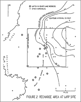
Figure 2 graphically displays the relationship between the western edge of the Santa Rosa sandstone and the locations of wells that produce water in the Dewey Lake Redbeds. Simply stated, the recharge area for the Dewey Lake Redbeds is everywhere that the Santa Rosa is not present.
The water in the Dewey Lake Redbeds is potable. Environmental Protection Agency (EPA) criteria for drinking water are twofold: (1) less than 10,000 milligrams per liter (mg/l) total dissolved solids (TDS); and (2) more than 5 gallons per minute (gpm) of water produced by the well. Water quality data for the Dewey Lake Redbeds are given in Table 2. Five private wells within eight miles of the WIPP site produce water of potable quality in the Dewey Lake Redbeds, but the quantity has never been measured. Three WIPP test wells produce water in sufficient quantity from the Dewey Lake Redbeds, but the quality has never been tested. At seven WIPP test wells, (and also at WIPP-33), water produced by the Dewey Lake Redbeds has never been tested for quality or quantity. At only one test well, WQSP-6a, has both the quality and quantity of water from the Dewey Lake Redbeds been tested, and it was found to meet both criteria for drinking water (3,920 to 4,238 mg/l TDS, 12 gpm). DOE claims (DOE/CAO 1996-2184, Appendix USDW, Table USDW-4) that test well WQSP-6a is not subject to EPA standards (40 CFR 191, Subpart C) because WQSP-6a is located on-site -- one mile southwest of the center of the WIPP site, 0.3 miles southwest of the waste emplacement panels (DOE/CAO 1996-2184, Figure 3-9). DOE says it is “possible” that other test wells are subject to EPA drinking water standards (DOE/CAO 1996-2184, Appendix USDW, Table USDW-4). DOE does not know because DOE has not done the necessary testing. P-17 is 3908 feet outside the WIPP site. WIPP-33 is 2854 feet outside the WIPP site. H-4c is 446 feet outside the WIPP site. All the private wells are outside the WIPP site. Until these wells are properly tested, it cannot be claimed that the Dewey Lake aquifer does not qualify as an underground source of drinking water under 40 CFR 191, Subpart C. Absence of evidence is not evidence of absence.
Directly underlying the Dewey Lake Redbeds is the Rustler Formation. In WIPP boreholes, outside of Nash Draw, the Rustler ranges in thickness from 276 feet at WIPP-33, a collapse sink, to 462 feet at P-18, considered to be a complete Rustler section. The Rustler is divided into five members, here described in descending order:
- the Forty-Niner member consists of 48 to 78 feet of broken and slumped gypsum with a bed of massive siltstone near the base;
- the Magenta dolomite, 19 to 28 feet thick, is a highly fractured aquifer;
- the Tamarisk member consists of 80 to 179 feet of anhydrite or gypsum with clay seams;
- the Culebra dolomite, 21 to 31 feet thick, also highly fractured, is the most transmissive unit of the Rustler aquifers; and
- the lower unnamed member consists of 72 to 150 feet of siltstone and very fine-grained sandstone, with interbedded gypsum or anhydrite.
The Culebra and Magenta dolomite members are persistent marker beds and reliable aquifers. In forty-one WIPP test wells, the Culebra was always saturated; the Magenta was dry at H-7 and WIPP-26, and absent at WIPP-29, all in Nash Draw (Mercer, 1983, Table 8). But water is sometimes found in the other members of the Rustler, even near the center of the WIPP site. Water was observed seeping into the WIPP ventilation shaft from a zone of solution residue in the Forty-Niner member, 17.7 to 30.2 feet above the Magenta; test well H-1 yielded as much water in the Tamarisk member as in the Culebra or Magenta; and test well H-3 yielded as much water in the lower unnamed member as in the Culebra or Magenta (EEG-32, 1985, pp. 37, 39). Potash test holes P-4, P-12, P-13 and P-17 hit water in the lower unnamed member.
Karst features have been observed in Dewey Lake siltstone, Forty-Niner gypsum, Magenta dolomite, Tamarisk anhydrite, and Culebra dolomite. Lost circulation of drilling fluid has been reported in the Dewey Lake Redbeds at H-7c, P-1, DOE-2, WIPP-25 and WIPP-33; in Forty-Niner gypsum at H-1 and WIPP-33; and in Magenta dolomite at WIPP-33. Four boreholes clustered near the center of the WIPP site have encountered washouts or loss of core in Tamarisk anhydrite (H-1, H-2, H-3 and ERDA-9). Five cavernous zones were encountered in Culebra dolomite at H-7c. Just three miles from the WIPP site in Nash Draw, at the Gnome Site turnoff, a surface exposure of Forty-Niner gypsum features a striking display of grikes, tunnels, caves, and collapse sinks; at least one of the caves is large enough to enter. These caves supply fresh water to deeper Rustler aquifers.
Thus it is shown that rainwater recharge to the Rustler Formation is possible, that no impermeable barrier exists above the Culebra dolomite. The question is whether or not rainwater recharge is actually occurring. This question can be answered by looking at the geochemistry of groundwater in the Culebra dolomite.
Total dissolved solids (TDS) in Culebra groundwater has been measured in 38 WIPP test wells [Table 3]. In some cases there have been multiple samplings at the same test well; in these cases the lowest measured values are presented in Table 3, as they are the most likely to represent mixing of groundwater with fresh water, and the least likely to represent contamination by brine from nearby injection wells. Table 3 reveals that TDS in Culebra groundwater in WIPP test wells vary by nearly two orders of magnitude, from 239,000 mg/l at WIPP-29 to 2,710 mg/l at H-8. When the wells are plotted on a map [Figure 1], it is shown that even within the WIPP site, TDS in Culebra groundwater vary by a factor of 25 -- from 230,000 mg/l at H-15 to 8,890 mg/l at H-2b. These two test wells are less than 8,750 feet (1.66 miles) apart.
Figure 1 shows contour lines of TDS at a contour interval of 50,000 mg/l. The contour lines display a zone of high TDS in the northeastern part of the WIPP site, where the Santa Rosa sandstone is present, with TDS steadily decreasing to the southwest, where the Santa Rosa is absent. This is consistent with the interpretation that Culebra groundwater becomes mixed with increasing amounts of fresh water as it approaches Nash Draw, because the hydrologic regime is increasingly karstic.
A similar observation was made by Chapman (EEG-39, 1988). She concluded (p. 35) that “the only plausible mechanism” for an order of magnitude decrease in TDS as Culebra groundwater moves along its flow path “is the influx of a large quantity of low TDS water. As no fresh-water aquifers are located in the WIPP area, the source of the fresh water must be surface water recharge.”
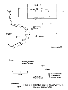
Test wells known to have produced water in the Dewey Lake Redbeds are depicted as bull's eyes in Figure 1. At ten of these wells, TDS in the Culebra dolomite were measured; and in seven of these, the lowest measurement was 36,000 mg/l or less (H-16 was measured only once). According to Ramey (EEG-31, 1985): “Waters with greater than 35,000 mg/l of total dissolved solids are classified as brines.” Thus, Culebra water in the recharge area, where the Santa Rosa is absent, is fresh enough not to be classified as brine. In fact, Culebra water at H-2b is potable (8,890 mg/l TDS). H-2b is on-site. DOE has tested the quality, but not the quantity, of Culebra water at H-2b. Five private wells within ten miles of the WIPP site produce water of potable quality in the Culebra dolomite, but the quantity has never been measured. Three test wells outside the WIPP site -- H-7b1, H-8b and H-9b -- produce water of sufficient quality and quantity (less than 10,000 mg/l TDS and more than 5 gpm) to meet EPA criteria and establish the Culebra as an underground source of drinking water under 40 CFR 191, Subpart C. Test well H-7b1 is located only 2.9 miles from the WIPP site, in Nash Draw, along a potential groundwater flow path from the WIPP site to the accessible environment. Water quality data for the Culebra dolomite are given in Table 4. Thirteen wells which produced potable water are shown in Figure 3.
 Conclusions:
- karst landforms exist at the WIPP site, and karst hydrology is active at the WIPP site today;
- ainwater infiltrates through solution pipes in Mescalero caliche, solution features in Gatuna sandstone, and fractures in Dewey Lake Redbeds;
- cavernous zones have been found, in WIPP boreholes, in Dewey Lake siltstone and in every member of the Rustler Formation -- in Forty-Niner gypsum, Magenta dolomite, Tamarisk anhydrite, Culebra dolomite, and mudstone of the lower unnamed member;
- water has been found at the WIPP site in the Dewey Lake Redbeds and in every member of the Rustler Formation;
- the Dewey Lake Redbeds and the Culebra dolomite contain potable water at and near the WIPP site, which can only be explained by rainwater recharge;
- the recharge area for the Dewey Lake Redbeds and the Rustler Formation is at and near the WIPP site, everywhere that the Santa Rosa sandstone is not present; and
- groundwater flow in the Rustler Formation is three-dimensional.