PhD, Geomorphology
University of Oregon
Doe is continuously modifying or attempting to modify WIPP's permit--sometimes trying to include waste treatment in the permit. So far they have not been allowed to add hazardous waste treatment at WIPP.
Dr. Phillips testified on many aspects of the geology and hydrology at WIPP during these hearings as a witness for CARD. Exhibits referred to in this paper were slides and overhead projections shown during his testimony and can be seen in the WIPP public record at NMED in Santa Fe, New Mexico. Some of these exhibits are also shown here.
Geomorphology is the study of landforms and the processes that create them and destroy them. Karst refers to landscapes that develop on soluble rocks such as limestone, dolomite, gypsum, anhydrite and halite. The most obvious surface characteristic is a lack of surface runoff. Rainwater infiltration is rapid and substantial, through sinkholes and disappearing streams and, in semi-arid climates, disappearing arroyos and perforated caprock. Drainage is almost entirely underground, through solution-enlarged fractures, channels, and caverns. Instead of seeping through innumerable pores as in sandstone, groundwater flows preferentially through discrete underground pathways, enlarging them by solution as it does so, and emerging at a few large, irregular springs (Phillips, 1987, pp. 34-41) (Phillips and Snow, 1998, 1-8).
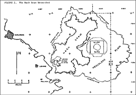
The WIPP site is located in the Pecos River Valley, one of the largest karstlands in the United States (LeGrand et al., 1976, Figure 1) [Exhibit 1]. The Pecos River Valley is famous for Santa Rosa sinks, Bottomless Lakes, and Carlsbad Caverns. East of the Pecos River lies the Mescalero Plain, a gently rolling landscape capped by Mescalero caliche and covered by a mantle of windblown sand (Phillips, 1987, Figure 1) [Exhibit 2]. Near the WIPP, the edge of the Mescalero Plain is marked by Livingston Ridge, an eastward-retreating escarpment (USGS memo, George O. Bachman to William P. Armstrong, 10/26/79). To the west, within one mile of the WIPP site, is Nash Draw, one of the largest surface karst features in the world (Phillips, 1987, Figure 2) [Exhibit 3].
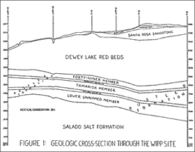
The WIPP repository is located 2150 feet below the surface in the Salado salt formation. Directly overlying the Salado is the Rustler Formation, the principal karstic aquifer in the vicinity. The Rustler is divided into five members, in descending order: the Forty-Niner, Magenta, Tamarisk, Culebra, and lower unnamed members (Phillips, 1997a, Figure 1) [Exhibit 4]. The Magenta dolomite and Culebra
 dolomite are persistent marker beds and reliable aquifers, being saturated in every WIPP test well east of Nash Draw (Phillips and Snow, 1997, Table 2). Where the Rustler is unaltered by solution, (for example, at test well P-18, considered to be a complete Rustler section), the Forty-Niner, Tamarisk, and lower unnamed members consist of alternating beds of anhydrite, halite and siltstone. However, in the presence of circulating groundwater, anhydrite converts to gypsum, and halite dissolves to mudstone. At the WIPP-33 borehole, no halite remains in the Rustler, and all anhydrite has been converted to gypsum (SAND 80-2011, pp. 15-21).
Isopach maps (SAND 82-1069, Figure 2.25) [Exhibit 5] show a westward thinning of the Rustler, from 440 feet thick at P-18, one mile east of the WIPP site, to 276 feet thick at WIPP-
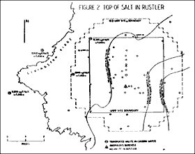 33, one-half mile west of the WIPP site. The reduction in thickness is wholly attributable to dissolution and removal of halite, and hydration of anhydrite to gypsum. As one moves westward across the WIPP site, halite is missing from successively lower members of the Rustler Formation (Phillips and Snow, 1997, Figure 2) [Exhibit 6]. This is consistent with the interpretation that dissolution of halite in the Rustler proceeds in a downward and eastward direction. Phillips and Snow (1997, p. 4) cite 15 reports by 21 authors who support this interpretation (see also Jones et al., attachment to USGS memo from Twenhofel to Schueler, 07/18/78). The extensive character of dissolution in the Rustler at WIPP is recognized by virtually all scientists who have examined this area (Anderson, 1996, p. 2) The works of two scientists on the DOE payroll does not “largely rule out this explanation,” as contended by DOE (CCA, p. 2-38) (Phillips, 1998a, p. 18)
The Rustler Formation at the WIPP site is overlain by the Dewey Lake Redbeds and, in the eastern half of the site, by the Santa Rosa sandstone [Exhibit 4]. This is known as a “covered karst,” the classic example in North America, where sandstone cover rocks impede but do not prevent rainwater infiltration to the underlying karstic aquifers (Phillips, 1987, p. 18) (Phillips and Snow, 1998, p. 8) (Sweeting, 1973, p. 59)
The United States Nuclear Regulatory Commission (NRC) published an entire report on the subject. The report is entitled: “Foundation Considerations in Siting of Nuclear Facilities in Karst Terrains and Other Areas Subject to Ground Collapse.” The authors warned that “filtration, which acts in porous media to remove many contaminants from the water, is virtually absent in the karst environment.” (Franklin et al., 1981, p. 57). Larry Barrows, when he was a geophysicist for Sandia National Laboratories, identified 16 reports by 20 authors who described karstlands as unreliable waste disposal environments. (Barrows, 1982, p. 17, reprinted as EEG-32, Appendix A). Nicholas Crawford, who is a Professor of Karst Hydrology at Western Kentucky University and is one of the leading experts on the subject of karst groundwater contamination, told the EPA: “One does not locate a hazardous waste site in, below, or near karst without an intensive karst hydrogeologic investigation.” (EPA Docket # A-93-02, Item # IV-G-42).
DOE states that “surface collapse features are characteristic of karst.” (Comment No. 273-I-5, p. 5). To the contrary, karst need not involve surface collapse. Phillips (1987, p. 193) cites 14 reports by 19 authors who describe sinkholes involving subsurface solution and surface subsidence without collapse at the surface.J. N. Jennings (1985, pp. 107, 111-112, cited by Phillips and Snow, 1998, p. A-10) calls them “subsidence dolines.” These are his words:
- Surface mapping can reveal the presence of closed topographic depressions, but cannot reveal whether or not they are of karstic origin. For example, the sinkholes at WIPP-14 and WIPP-33, and the karst valley in the southwestern part of the WIPP site, are all shown on USGS topographic maps, but subsurface exploration was necessary to establish their origins (Phillips, 1987, Chapters IV, V and VII).
- Geophysical techniques did find evidence of karst. The WIPP site gravity survey (Barrows et al., 1983, SAND82-2922) found negative gravity anomalies beneath WIPP-14 and WIPP-33, which the authors attributed to karst conduits. The WIPP site resistivity survey (Elliot Geophysical Company, 12/22/76, p. 34) identified the WIPP-14 depression as a “sinkhole due to solution caverning.” It also showed low resistivity at WIPP-33 and in the eastern end of the karst valley, where my backhoe trenches were located (SW 1/4 sec 30, T 22 S, R 31 E).
- Drillholes did find evidence of karst. According to lithologic logs, five water-filled channels were found at WIPP-33 -- one in Dewey Lake Redbeds (357.0-364.0 ft), two in Forty-Niner gypsum (416.5-426.0 ft, 430.0-436.0 ft), and two in Magenta dolomite (452.0-
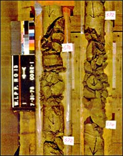 454.0 ft, 462.0-467.0 ft). According to lithologic logs, mud-filled channels were found in the Forty-Niner member at H-3b2 (534.3-539.3, 543.0-545.1 ft), in the Tamarisk member at H-6c (580.0-605.0 ft), and in the unnamed lower member at H-6c (625.0-640.0 ft) and WIPP-14 (836.2-907.6). According to lithologic logs and photographs of core at WIPP-13, the Magenta dolomite is leached, broken and shattered (570.0-581.0 ft) (Core 1, Plates 1-6) [Exhibit 7 and Exhibit 8], and collapse breccia was found in the underlying Tamarisk member (676.2-687.6 ft) (Core 5, Plates 21-26) [Exhibits 9 and 10] (EPA Docket # A-93-02, Item # V-C-1, p. 3-99).
- Hydrologic testing has found hydraulic connections and zones of high transmissivity along two flow paths from the WIPP site to the accessible environment -- from H-3 to DOE-1 to H-11 to P-17, and from the WIPP exhaust shaft to WIPP-13 to WIPP-33 to WIPP-25 (Phillips and Snow, 1997, pp. 10-13) (Phillips, 1998a, pp. 2-3, 8-11) (Phillips and Snow, 1998, pp. 14-18). To say that hydrologic testing has found no evidence of karst is disingenuous because the boreholes at WIPP-14 and WIPP-33 were never converted to hydrologic test wells, despite their obvious potential for karst hydrogeologic investigation.
-
Shaft construction resulted in deep washouts that required the installation of ten-foot steel
liner plates to prevent further caving of the shaft walls. In the WIPP ventilation shaft (later enlarged to be the waste handling shaft) five such liner plates were required, one in the
Forty-Niner member, one in the Tamarisk member, two in the unnamed lower member, and
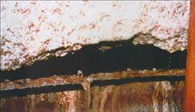 one at the Rustler-Salado contact (TME 3171, Table 2, reprinted in TME 3177). One of these washouts, in a mudstone layer immediately beneath the Culebra, was 6.7 feet from top to bottom, and extended 2.5 feet deep into the shaft wall (Phillips, 1987, Plate 27) [Exhibit 11]. Water seeps into the shaft at this level, and as much as one foot of water has collected in the tunnel, now barricaded, leading northward from the waste handling shaft. (Phillips, 1987, Plates 24 and 25).
- Underground mining revealed no evidence of karst. One would not expect to find it in the Salado Formation.
- Notably, DOE does not mention air photo interpretation, hand augering, and backhoe trenches, which did find evidence of karst in Mescalero caliche, within the WIPP site.