If these zones appeared only in the WIPP ventilation shaft, or elsewhere but rarely, it might be reasonable to regard them as “washed out zones” attributable to drilling fluid. However, both of these zones can be correlated across the WIPP site, with a consistent lack of core recovery. Both zones are poorly consolidated, probably transmissive, and possibly cavernous.
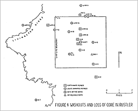
In the zone above the Magenta dolomite there was loss of core, washout, and/or loss of circulation at H-7, H-11b3, H-3b3, H-1, WIPP-19, WIPP-12, DOE-2, WIPP-34, H-16, H-18 and WIPP-33. In the zone below the Culebra dolomite there was loss of core or cuttings at H-11b3, H-3b3, P-1, H-14, H-15, H-18, P-12, WIPP-13, WIPP-11, DOE-2, WIPP-34, and WIPP-14. Detailed summaries of these cavernous encounters, compiled almost entirely from geophysical logs and lithologic descriptions, with occasional reliance on Chaturvedi and Channell (EEG-32, 1985), are given in Table 2 and Table 3. The boreholes are mapped in Figure 4.
Dissolution residue was reported in the Forty-Niner member, within 15 to 18 feet of the Magenta, but with no loss of core, at ERDA-9, WIPP-18, WIPP-19, WIPP-21, WIPP-22, and WIPP-13. Dissolution residue was reported in the lower unnamed member, within 2 to 4 feet of the Culebra, but with no loss of core, at ERDA-9, WIPP-18, WIPP-21, WIPP-22, H-6, and WIPP-33.
All the boreholes listed above are located at the WIPP site or within one mile of the WIPP site. In addition, at borehole H-7c, located 2.9 miles southwest of the WIPP site in Nash Draw, there was loss of core at 273.5 to 280.0 feet below the land surface, immediately below the Culebra dolomite. At borehole WIPP-25, located 2.5 miles west of the WIPP site in Nash Draw, there was lost circulation of drilling fluid at 522 to 526 feet below the land surface, within a 20.6-foot section of mud in the lower unnamed member of the Rustler Formation.
There is another dissolution residue zone in the Tamarisk member of the Rustler Formation. Four boreholes clustered near the center of the WIPP site have encountered washouts or loss of core in Tamarisk anhydrite: at H-1 (650.0-653.5 feet below land surface, 22.5 feet above the Culebra); at H-2a (593.0-606.0 feet below land surface, 17.0 feet above the Culebra); at H-3b3 (645.5-652.5 feet below land surface, 19.5 feet above the Culebra); and at ERDA-9 (690.0-698.0 feet below land surface, 6.0 feet above the Culebra). At the same horizon in the Tamarisk member, dissolution residue was encountered in the WIPP ventilation shaft and along two paths leading away from ERDA-9: northward at WIPP-21, WIPP-22, WIPP-19 and WIPP-18, and northwestward at H-18, WIPP-13 and H-6.
Caverns are known to occur in the Dewey Lake Redbeds as well. The lithologic log for borehole H-7c reports “boulders caving in” at 59 feet below the land surface. Lost circulation of drilling fluid in the Dewey Lake Redbeds has been reported at H-7c (24 feet above the Rustler), at WIPP-33 (37 feet above the Rustler), at WIPP-25 (124 to 154 feet above the Rustler), at P-1 (180 feet above the Rustler), and at DOE-2 (400 feet above the Rustler).
This correlation of cavernous zones raises two questions: (1) are karst conditions expressed at the land surface; and (2) if so, is WIPP hydrologic data representative of karst conditions?
Every karstland has sinkholes in the land surface. Two types of sinkholes are recognized: (1) collapse sinks, formed when surface rocks collapse abruptly into underground caverns; and (2) alluvial dolines, or solution-subsidence dolines, formed when surface rocks subside slowly due to solution of underlying rocks; these are flooded after major rainstorms and become filled with alluvial sediments. Collapse sinks are more common where soluble rocks are exposed at the land surface; alluvial dolines are more common where soluble rocks are overlain by sandstones, as at the WIPP site.
West of the WIPP site is Nash Draw, one of the largest karst features with surface expression in the world. Nash Draw is a huge depression, 18 miles long and 10 miles wide, formed by the coalescence of thousands of sink holes. The H-7 test wells were drilled into one of the sinks in Nash Draw; it is located near the western end of an obvious karst valley, walled on both sides by high dunes, and plainly visible in the WIPP site air photos. There are ephemeral water courses draining into the valley from the sides, but upon entering the valley these watercourses disappear underground. At borehole H-7c a cavern was encountered in the Dewey Lake Redbeds, with lost circulation of drilling fluid and “boulders caving in.” The Culebra dolomite was broken into six sections totaling 24.3 feet, separated by five cavities totaling 21.7 feet; this was underlain by 6.2 feet of mud, beneath which there was no core for 80.8 feet. Transmissivity in the Culebra dolomite was 1430 ft2/day, the highest measurement at any of the forty-one WIPP test wells.
The most obvious sinkhole in the WIPP site vicinity is WIPP-33, located in sec 13, T 22 S, R 30 E. It is a closed topographic depression about 700 feet in diameter and 30 feet deep. It is prominent on the WIPP site air photos, and is shown on the USGS topographic maps. One of the few small arroyos in the WIPP site vicinity drains into this depression. It is floored with matted leaves, organic matter, and desiccated clay, indicating occasional flooding of the depression. Evidence of surface collapse can be seen in the caliche escarpment at its southeastern rim. Evidence of subsurface collapse was seen in backhoe trenches, where caliche breaks off abruptly, with near-vertical drops of four feet to the sandstone bedrock surface. Joint-controlled solution features were found in carbonate-cemented sandstone beneath the caliche. In the WIPP site gravity survey, a negative gravity anomaly of high amplitude was measured, originating no deeper than the Magenta dolomite. Borehole WIPP-33, drilled into this depression, encountered 44 feet of alluvial fill, and five underground caverns filled with water--one in Dewey Lake siltstone, two in Forty-Niner gypsum, two in Magenta dolomite. In the Rustler Formation, all anhydrite has been converted to gypsum, and all halite has been dissolved and removed; salt dissolution has also affected the top of the Salado Formation.
Three other sinkholes form a chain trending west-southwestward, directly toward WIPP-33, implying an underground flow path beneath them. All are visible in the WIPP site air photos, and all are underlain by structural depressions in the caliche surface. The westernmost sinkhole is 400 feet long, 200 feet wide, 2 to 4 feet deep, is floored by organic debris and desiccated clay, is saturated after rainstorms, contains at least 24 feet of alluvial fill, and swallows some of the water from the WIPP-33 arroyo. The second sinkhole is 300 feet long, 200 feet wide, 8 to 10 feet deep, and is not as well developed, being floored by sand with a weak clay pan and only partly filled with alluvial sediments, although non-incised water courses are present on its slopes. The easternmost sinkhole is 300 feet long, 150 feet wide, 2 feet deep, is floored by organic debris and desiccated clay, is saturated after rainstorms, contains up to 20 feet of alluvial fill, and has an arroyo disappearing into it. This arroyo formed suddenly during the heavy rains of September 18-19, 1985, only to be swallowed by the sinkhole; this is direct evidence of active karst processes. This same rainstorm filled the WIPP-33 sinkhole with 5.0 feet of standing water, which infiltrated within days.
Another sinkhole in the WIPP site vicinity is WIPP-14, located in secs 9 and 16, T 22 S, R 31 E. It is 600 to 700 feet in diameter, 9 feet deep, and is shown on the USGS topographic maps. Draining into the WIPP-14 depression are at least five ephemeral water courses. It is floored by windblown sand, organic debris, and desiccated clay. No collapse is evident at the surface, but such evidence could be obscured by 8 to 15 feet of dune sands that have accumulated on the crests of the depression. It is underlain by a structural depression in the caliche surface, 400 to 650 feet in diameter and 6 feet deep. Gleyed sediments were observed in trench exposures, indicating past ponding, when perched water accumulated in the depression and caliche became extremely leached and degraded, leaving only remnants pockmarked with solution features. Carbonate-filled fractures in Santa Rosa sandstone beneath the caliche are direct evidence of rainwater infiltration. The depression is underlain by a high-amplitude negative gravity anomaly. Borehole WIPP-14, drilled into this depression, encountered 15.4 feet of alluvial fill; there was 243.1 feet of lost core, including 71.4 feet of mud with gypsum and anhydrite fragments directly below the Culebra; halitic mudstone was found in the lower 3.7 feet of the Rustler Formation; all other halite has been dissolved and removed.
There are now 27 hydrologic test wells within one mile of the WIPP site. Six of them (DOE-2, WIPP-13, H-6, H-3, DOE-1, H-11) may be representative of fracture flow in the Culebra, but none are known to be representative of karst conditions. WIPP-33 is located one-half mile from the WIPP site, and WIPP-14 is located within 100 feet of the WIPP site. There is no excuse for not converting these existing boreholes into hydrologic test wells. The simplest explanation is that the DOE is not interested in karst.