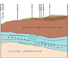
The Rustler Formation thins to the west, across the WIPP site because the salt (halite) in the formation is being dissolved away and other minerals are being altered. East of the WIPP site, where water has not eroded away the sedimentary rock in the Rustler, its members consist of alternating beds of anhydrite, halite and siltstone. Where there is moving groundwater, however, the anhydrite is changed to gypsum and the halite dissolves to mudstone. Moving west across the WIPP site, halite is missing from successively lower members of the Rustler.
The Culebra Dolomite member of the Rustler has gypsum filled fractures throughout which are leached out from east to west. When this gypsum is glassy (selenite), this is proof that it has evolved by dissolution and groundwater flow. The partially open fractures in the Culebra are the main reason for the ease of water flow in that member. Unfortunately, DOE has not done the slant boring necessary to adequately characterize these vertical fractures.
The groundwater geochemistry of the Culebra also demonstrates the same pattern. DOE models the Culebra as a 'confined' aquifer meaning that it receives virtually no rainwater recharge through the formations above it. If this were true, however, the water in the Culebra would be saturated with salts or almost so. In fact, the total dissolved solids (TDS) in Culebra groundwater within the WIPP site vary by a factor of 25 between two wells only a little more than a mile and a half apart. Where the Santa Rosa sandstone is present and water is not found in the Dewey Lake Redbeds, TDS are high. This is in the northeastern part of the site. TDS decrease as you go to the southwest where the Santa Rosa is gone and there is water in the Dewey Lake Redbeds. Culebra groundwater is being mixed with increasing amounts of fresh water from above as it moves west because the area is increasingly karstic.
The Magenta Dolomite also shows evidence of karst. Test wells have found water-filled caverns, a shattered structure and in places faster potential flowtimes than in the Culebra. There isn't enough data, however, to model the Magenta as a potential migration pathway.
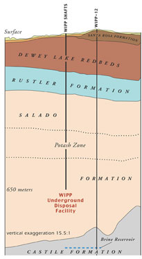
If contamination from the repository reached one of these interbeds, it could be carried more easily to the outside environment. Marker Bed 138 is 20 feet above the repository roof and Marker Bed 139 is 5 feet below the floor. (Actually, now, the floor has been milled virtually all the way down to Marker Bed 139 in some areas of the repository.) There are other, smaller, interbeds inbetween. Once the repository is connected to these marker beds, it too is connected to every borehole and shaft in the basin.
Above the repository, but still in the Salado, is an area with high concentrations of potash. Potash is another type of salt and is important for agriculture. Most of the potash reserves in the United States are above and right around WIPP. Although mining this potash is now prohibited, how long will DOE really be able to keep control over this area? Sooner than we think, people will be mining this resource, possibly using waterflooding to do so. This could cause subsidence fracturing above the potash mines which could make connections to the waterbearing layers in the Rustler Formation above. And it could continue this connection to any subsidence fracturing that had occurred above the excavated WIPP repository below. (See The Facility/Subsidence Fracturing)
WIPP-14 is one of about 10 sinkholes which curve around the northeast boundary of the site. WIPP-14 itself is actually right on the site boundary. The WIPP-14 depression is of interest because it gives evidence of karst far to the east of where DOE describes the dissolution front. The authors of the 1976 WIPP site resistivity survey described the depression at WIPP-14 as a "...sinkhole due to solution caverning." (Underground caverns that have been dissolved away by water movement are typical karst features.) In addition, mudfilled channels were found here in the Unnamed Lower member and a 71 foot section of mud and fragments of gypsum and anhydrite were found below the Culebra Dolomite, indicating a former flow channel. DOE now says there is no evidence of karst at WIPP-14.
WIPP-33, one half mile west of the WIPP site, is the westernmost of 4 sinkholes. The easternmost of these is only 1000 feet from the WIPP site boundary. Five water-filled channels were found at WIPP-33 in the Magenta Dolomite and higher layers, and the depression showed low resistivity during the 1976 survey (as did WIPP-14). At
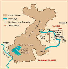 WIPP-33, there is no salt left in the Rustler and all the anhydrite has been converted to gypsum. This is clear evidence that water has flowed through this area and even the DOE admits that these are karstic structures. However, they claim that WIPP-33 is only a finger of dissolution that extends out from Nash Draw and that the site is still behind the dissolution line. DOE has refused to turn the boreholes at WIPP-14 and WIPP-33 into test wells.
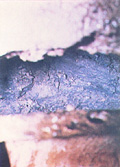 The southwestern flow path from H-3 to DOE-1 to H11 is primarily through the Culebra and the Unnamed Lower member. It should be noted that test well H-3 is only 400 feet south of the waste panels. Cavernous 'washout zones,' where dissolution residue was washed away during excavation, were found in the Waste Handling Shaft just below the Culebra Dolomite (see photo on left). DOE has only modeled this pathway as far as the WIPP site boundary and unfortunately, has done very little study in general of the Unnamed Lower member. In the northern part of the site, a multiwell pump test was done at WIPP-13, but all the monitoring wells were in the Culebra even though evidence indicates that the northwestern pathway is actually in the Magenta and higher strata. (That is where the water-filled caverns were found at WIPP-33.) Even so, testing showed that at test well H-3 transmissivity (the ability for fluids to move easily through a formation) in the Magenta is more than 17 times what it is in the Culebra; at WIPP-25 transmissivity in the Magenta is 1.4 time that in the Culebra. Unfortunately, there is little data on the Magenta and further testing needs to be done to define the locations of the karst conduits there.
Under karst conditions, contaminants can travel at the speed of flowing water. Under optimum conditions travel times could be as short as ten years from the WIPP repository to Laguna Grande. Plutonium and other heavy metals would concentrate in the lake sediments until they were flushed out by major flooding onto the land and into the Loving Canal, an irrigation canal which connects to the Pecos River. Thus the waste at WIPP could travel to the Pecos River and from there to the Rio Grande.
Among other tests, WIPP-33 and WIPP-14 need to be turned into test wells and dye tracer tests need to be done along the most likely pathways to see truly how long it takes water to flow along these paths. DOE needs to make use of new technology which for relatively little money could give us a clear picture of karst structures over the site if they do, indeed, exist. The danger from the short travel times which could exist under karstic conditions is so great that this is an issue which cannot be ignored. Every 5 years DOE must prove to the Environmental Protection Agency that WIPP can still contain the waste for 10,000 years. The next review is in 2004. If the real geological picture of the site could be shown, it is still possible that the WIPP Project could be shut down.